


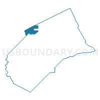
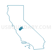
Voting District 40350, Merced County, California
About
Outline

Summary
| Unique Area Identifier | 535159 |
| Name | Voting District 40350 |
| County | Merced County |
| State | California |
| Area (square miles) | 39.73 |
| Land Area (square miles) | 39.47 |
| Water Area (square miles) | 0.26 |
| % of Land Area | 99.34 |
| % of Water Area | 0.66 |
| Latitude of the Internal Point | 37.39987080 |
| Longtitude of the Internal Point | -120.89536130 |
Maps

Graphs
Select a template below for downloading or customizing gragh for Voting District 40350, Merced County, California


Neighbors
Neighoring Voting District (by Name) Neighboring Voting District on the Map
- Voting District 20390, Stanislaus County, CA
- Voting District 20395, Stanislaus County, CA
- Voting District 20415, Stanislaus County, CA
- Voting District 40340, Merced County, CA
- Voting District 40355, Merced County, CA
- Voting District 40365, Merced County, CA
- Voting District 40450, Merced County, CA
- Voting District 40520, Merced County, CA
- Voting District 51050, Stanislaus County, CA
- Voting District 51055, Stanislaus County, CA
Top 10 Neighboring County Subdivision (by Population) Neighboring County Subdivision on the Map
- Turlock CCD, Stanislaus County, CA (82,457)
- Livingston-Delhi CCD, Merced County, CA (30,803)
- Newman CCD, Stanislaus County, CA (12,321)
- Hilmar-Irwin CCD, Merced County, CA (9,905)
Top 10 Neighboring Place (by Population) Neighboring Place on the Map
Top 10 Neighboring Elementary School District (by Population) Neighboring Elementary School District on the Map
- Livingston Union Elementary School District, CA (15,498)
- Chatom Union Elementary School District, CA (4,459)
Top 10 Neighboring Secondary School District (by Population) Neighboring Secondary School District on the Map
- Merced Union High School District, CA (166,634)
- Turlock Unified School District in Chatom Union, CA (4,467)
Top 10 Neighboring Unified School District (by Population) Neighboring Unified School District on the Map
- Turlock Unified School District, CA (70,650)
- Newman-Crows Landing Unified School District, CA (13,180)
- Delhi Unified School District, CA (12,847)
- Hilmar Unified School District, CA (9,898)
Top 10 Neighboring State Legislative District Lower Chamber (by Population) Neighboring State Legislative District Lower Chamber on the Map
Top 10 Neighboring State Legislative District Upper Chamber (by Population) Neighboring State Legislative District Upper Chamber on the Map
Top 10 Neighboring 111th Congressional District (by Population) Neighboring 111th Congressional District on the Map
Top 10 Neighboring Census Tract (by Population) Neighboring Census Tract on the Map
- Census Tract 4.02, Merced County, CA (8,071)
- Census Tract 37, Stanislaus County, CA (4,796)
- Census Tract 36.03, Stanislaus County, CA (3,952)
- Census Tract 3.03, Merced County, CA (2,158)
- Census Tract 2.02, Merced County, CA (1,841)
- Census Tract 4.01, Merced County, CA (1,834)
- Census Tract 34, Stanislaus County, CA (1,601)
Top 10 Neighboring 5-Digit ZIP Code Tabulation Area (by Population) Neighboring 5-Digit ZIP Code Tabulation Area on the Map
- 95380, CA (41,201)
- 95334, CA (15,457)
- 95315, CA (13,018)
- 95360, CA (11,712)
- 95324, CA (7,324)
- 95374, CA (2,030)
- 95313, CA (1,386)